
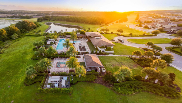
I sell drone photography, so this may sound strange coming from me: not every real estate listing needs drone photos.
There are properties where I would absolutely recommend flying.
There are others where I can put the drone 150 feet in the air, take ten technically good photographs and still not tell the buyer anything useful about the house.
That is the difference I care about.
A drone photo should reveal something the ground-level photos cannot.
The Question I Ask Before I Fly
I do not start by asking, “Can I get the drone up?”
I start by looking at the property and asking:
Sometimes the answer is obvious.
The home sits on a lake. The lot is unusually large. The property has a dock hidden behind the house. The clubhouse is nearby. There is an outdoor living area that only makes sense when you see how the pool, lanai and home connect.
Those are reasons to fly.
“Drone looks premium” is not enough by itself.
A Real Example: The Photo I Could Not Make From the Ground
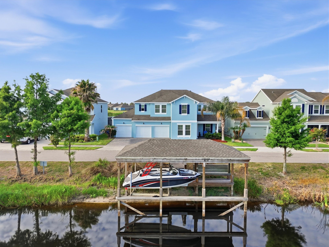
A waterfront property I photographed in Groveland is probably the clearest example.
The client wanted to see the house and his boat together in one photograph.
From the ground, I could photograph the house.
I could photograph the dock.
I could photograph the boat.
What I could not do was put all of that information into one clean frame.
The drone solved that immediately.
That photograph did not exist because aerial photography was “cool.”
The camera needed an aerial position to show that relationship in one frame.
“Drone footage turned out amazing.”
That is what I want from aerial media: not another angle, but an angle that actually earns its place in the gallery.
Groveland waterfront drone case study
When Drone Photography Usually Makes Sense
Lake, Canal or Dock
Aerial photography can show the relationship between the house, shoreline, dock, water and surrounding environment in a way ground photography often cannot.
Large Lots & Land
When the land is an important part of what is being sold, elevation can help buyers understand scale, openness and how the home sits within the property.
Amenities & Context
For some Orlando communities, the clubhouse, pool, golf, lake or amenity center is part of the lifestyle story. Drone can help explain that relationship.
Pool + Lanai + Home
An elevated angle can make the connection between the architecture and outdoor spaces much easier to understand.
Community Scale
Builders and developers may need an aerial view to show streets, phases, model homes, amenities and the broader development rather than one structure alone.
Meaningful Proximity
If a real location advantage can actually be seen from the air, aerial photography can explain context better than another interior image ever could.
Acreage Is One of the Easiest Drone Decisions
If I am photographing four acres, ground-level photographs have a basic limitation: I am standing inside the thing I am trying to explain.
I can photograph trees, open space, a fence or a driveway.
But the buyer may still have no idea how those pieces relate to each other.
That is an important distinction.
But Be Careful With Property Lines
An aerial photograph can help show land.
It does not automatically establish a legal property boundary.
I would never tell a buyer that a visible fence, tree line or edge in an aerial photograph is the legal property line unless that information comes from an appropriate verified source.
Drone photography shows context.
Those are not the same thing.
Community Amenities Are Another Good Use
This happens frequently around Central Florida.
A Realtor may tell a buyer that the property is close to the community pool or clubhouse.
That is useful information.
But if the aerial image can actually show the home, the street and that amenity in a meaningful relationship, now the photograph is explaining something.
That is much stronger than simply putting the drone high enough to see hundreds of rooftops.
When I Would Not Prioritize Drone
Sometimes the aerial view makes the story weaker.
This can happen with a straightforward home in a dense subdivision where the elevated view mostly reveals:
- Neighboring roofs
- Parking lots
- Utility infrastructure
- Commercial buildings behind the community
- No meaningful lot or location advantage
- No pool, lake, acreage or architectural relationship that benefits from elevation
That does not mean I cannot produce attractive drone photographs.
It means I have to ask whether attractive is enough.
If the Realtor has a limited marketing budget, I may prefer that money go toward something buyers will actually use—perhaps a floor plan, 3D tour or short-form video.
The Most Expensive Media Is Media Nobody Uses
This is one of the principles I have changed my mind about as my real estate work has grown.
Years ago, I was more likely to think:
I do not believe that anymore.
A Realtor can order photography, drone, video, FPV, 3D, floor plan and social Reels.
That does not automatically make the marketing better.
The listing becomes stronger when each asset has a job.
What About Luxury Listings?
Luxury listings often benefit from drone because the property itself may have more to explain: larger lots, architectural scale, water, golf, outdoor living or community context.
But I still would not make drone automatic just because the listing price is high.
A million-dollar price tag is not a flight plan.
I look at the house first.
What About Vacation Homes?
Around Orlando, vacation homes can be interesting because the selling point is often bigger than the building itself.
A pool, resort clubhouse, water park, sports courts or community layout may be part of what an owner is marketing.
In those cases, aerial coverage can help tell that broader story.
But again, I want the aerial frame to explain something—not simply prove that I own a drone.
What About Roof Photos?
A drone can create useful visual documentation of a roof from above.
But I make a clear distinction:
Aerial photography is not a roof inspection.
I am a photographer and remote pilot, not a licensed home inspector evaluating the condition or remaining life of roofing materials.
The photograph can show what is visible.
The professional interpretation belongs to the appropriate inspector.
Sometimes I Cannot Fly When We Planned To
This is another part of professional drone work that clients do not always see.
At the Groveland waterfront property, I had to postpone part of the aerial work because of a temporary flight restriction.
I returned when the flight could legally be completed.
Would it have been easier to send the drone up anyway?
Of course.
That was not an option.
What I Check Before a Real Estate Drone Flight
As an FAA Part 107 Certified Remote Pilot, the flight decision is not only creative.
There is an aviation decision happening too.
Before I Fly
- I evaluate the airspace around the property
- I check whether controlled-airspace authorization is required
- I review temporary flight restrictions and other relevant restrictions
- I look at weather and wind conditions
- I consider people, vehicles, obstacles and the surrounding environment
- I decide whether the planned flight can be completed safely and legally
The FAA requires authorization before Part 107 operations in controlled Class B, C, D and certain Class E airspace. LAANC can provide near-real-time authorization for many operations at approved altitudes. Temporary Flight Restrictions can also affect whether a planned flight can legally occur. [1][2]
That is one reason hiring a commercial drone pilot is not the same thing as asking someone to “just grab a couple shots from the air.”
Higher Is Not Automatically Better
One mistake I see in aerial real estate photography is the idea that the drone needs to go as high as possible.
Usually, that is not where my favorite image comes from.
Sometimes the strongest aerial photograph is only slightly elevated above roof level.
That angle can show the pool, yard and architecture while the house still feels like the subject.
The goal is to find the altitude where the property makes sense.
My Simple Decision Matrix
Five Questions I Would Ask Before Adding Drone
Before you add aerial photography, ask:
- Is there something important about the property that cannot be shown well from ground level?
- Is the lot, water, pool, acreage or community part of the selling story?
- Will an elevated angle explain the property—or just show more neighboring roofs?
- Do I know where and how I will use the aerial images?
- If the budget is limited, is drone more useful here than another media option?
The Drone Photo Has to Earn Its Place
When I photograph a listing, I do not want the aerial section to exist because somebody checked a box called “Drone.”
I want at least one image where the Realtor can immediately say:
That is the standard.
And if I cannot find a good reason for the drone to be there, I would rather be honest about that than pretend every property needs the same media package.
Frequently Asked Questions
Does every real estate listing need drone photography?
No. Drone photography is most useful when the aerial perspective reveals important information about the property, land, water, outdoor spaces, amenities or location that ground-level photography cannot explain as clearly.
Is drone photography worth it for a small house?
It can be, but house size alone is not the deciding factor. A small waterfront property or a home with an important location relationship may benefit from drone more than a much larger home with no meaningful aerial story.
Is drone photography good for waterfront homes?
Often, yes. It can show the relationship between the home, shoreline, dock, boat, water and surrounding environment in one frame.
Can drone photos show property boundaries?
Aerial images can show the land visually, but they should not be treated as a legal survey. Property boundaries should come from appropriate verified documentation.
Can you always fly a drone at a real estate property?
No. Airspace, temporary restrictions, weather, safety conditions and other operational factors can affect whether and when a flight can legally and safely take place.
Do real estate drone pilots need FAA certification?
Commercial real estate drone operations in the United States fall under FAA rules including Part 107 requirements. Magic Lens drone work is performed by an FAA Part 107 Certified Remote Pilot.
Do drone photos help a home sell faster?
I would not promise that. Drone photography is a presentation tool. Its value is in showing property information and context that may otherwise be difficult to communicate visually.
Your Listing May Need a Drone. It May Not.
I would rather help you choose the media the property actually needs than add another service just because it is available.
Magic Lens provides professional real estate photography, drone media, video, Reels, Zillow 3D tours and floor plans throughout Orlando and Central Florida.

Gustavo Sousa
Gustavo Sousa is a professional real estate photographer, videographer and FAA Part 107 Certified Remote Pilot based in Winter Garden, Florida.
A professional photographer since 2012, he works with Realtors, residential listings, vacation homes, builders and real estate projects throughout Orlando and Central Florida.
References
[1] Federal Aviation Administration — Part 107 Airspace Authorizations
FAA guidance on controlled airspace authorizations and LAANC
[2] Federal Aviation Administration — Temporary Flight Restrictions
FAA guidance on Temporary Flight Restrictions for drone operations
Magic Lens Case Study — Groveland Waterfront Property
See the real project where the aerial image solved a problem ground photography could not